

Santa Cruz is home to a bounty of beautiful open space and some of the best mountain bike trails in the country. Here you’ll find info on some of the areas we guide and recommend checking out.
Ready to ride the best Santa Cruz mountain bike trails? Join one of our expert guides for an unforgettable experience — book your guided ride today!
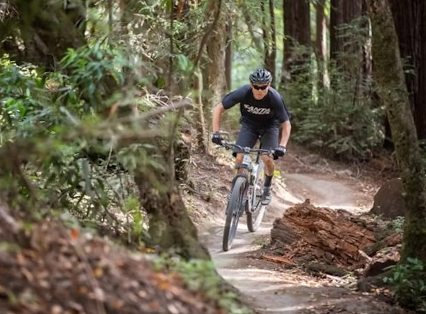
Soquel Demonstration State Forest “Demo” | map

Just a 35-40 minute jaunt from Santa Cruz nestled on a high ridge, Demo is home to the now world-famous flow trail and several other extremely popular bay area local favorites. These trails are intermediate to advanced, require a good amount of fitness to access and unfortunately e-bikes are not permitted.
Trails include:
- Braille | advanced, natural old school DH, some drops and features to side of trail
- Sawpit | *currently under construction
- Ridge | intermediate, technical sections peppered in, all other DH trails start from this trail
- Corral | intermediate, ripping fast but short downhill with some optional small drops/jumps, mostly flowy buff singletrack
- Demo Flow | intermediate to advanced, 4 miles (6 sections) of mega berms, jumps and ripping fast flowy awesomeness. Spectacular trail that will leave you grinning like you just rode a Six Flags rollercoaster made of dirt!
Wilder Ranch SP | map

Wilder Ranch State Park is one of the largest and most spectacular parks in Santa Cruz County, with over 7000 acres of varied terrain. Expansive open grasslands with sweeping ocean views contrasted with deep valleys covered in lush ferns and tall redwood forest.
Trails:
- Wilder Ridge Loop (6.3 miles) and Enchanted Loop (2 miles) | both offer some of the park’s best views and redwoods
- Engelsmans Loop
- Wild Boar to Old Cabin (2.9 miles)
- Eucalyptus Loop
- Baldwin Loop
- Chinquapin
- Long Meadow
Pogonip | map

Within the city limits of Santa Cruz and just north of the downtown area. Pogonip is home to two of the most popular trails in the area and has stunning views of the city skyline and Monterey Bay.
Trails:
- Emma McCrary | fun flow-type multi-directional trail that connects to U-Conn
- U-Conn | similar to EMC and connects to upper campus of UCSC and over to Wilder Ranch
Big Basin Redwoods SP | map

Big Basin Redwoods is California’s oldest state park, nestled right in the heart of the Santa Cruz Mountains. Towering ancient redwoods, lush forest and views of the Pacific ocean from granite peaks, Big Basin Redwoods SP is truly a sight to see. The bicycle access is limited to fire roads only, but certainly worth a pedal to see the majestic beauty.
Delaveaga | map

“Dela” is home to a small network of very fun singletrack trails with varied terrain snaking their way along redwood covered hillside and ravines. Mostly buff and flowy trails, natural hillside berms and some technical roots & drops peppered in. Dela is a beautifully maintained park, great for all age groups and families with ample parking, grassy fields, picnic areas and clean restrooms. Conveniently located within a 5 minute drive from downtown.
Trails:
- Top of the World / La Corona | easy/moderate “lollipop” type loop with some advanced technical features peppered in, a spectacular view of the entire Monterey Bay from the top
- Redwood / DeLaveaga Upper Loops | fun fast and flowy trails that can all be linked together for a grin inducing lunch ride
University of California Santa Cruz – UCSC | map

The upper redwood forest of the UCSC campus connects the Pogonip and Henry Cowell areas to Wilder Ranch. Currently all singletrack trails other than the fire roads are not open to bicycle use.
Forest of Nisene Marks SP | map
Nisene includes a small network of beginner friendly trails near the entrance and bottom of the park. If you’re interested in the monstrous 13-mile climb to the top of the ridge, you’ll be rewarded with the amazing trails of “Demo” for an epic day on the bike.
Trails:
- Aptos Rancho Trail | beginner, smooth and flowy trail running parallel to the upper fire road
- Terrace Trail | intermediate, some challenging bits mixed in with creek crossings